Location data is a cornerstone of many applications, from simple address lookup services to complex logistics solutions. Whether you’re running an e-commerce platform that needs to pinpoint delivery locations or a ridesharing app guiding drivers, geocoding is the backbone of these services. Here’s where Google Maps Platform’s Geocoding API comes into play. This powerful tool is used for converting between addresses and geographic coordinates and now it’s enhanced with a new feature. Read on to learn all the details!
What is the Geocoding API?
The Geocoding API is a service offered by Google Maps Platform that allows developers to convert addresses into geographic coordinates (latitude and longitude) or Place IDs, and vice versa. This process, known as geocoding, is crucial for mapping and location-based services. The opposite process, reverse geocoding, converts geographic coordinates or Place IDs into human-readable addresses, which is essential for services like delivery, routing, and location tagging.
How Does the Geocoding API Work?
The Geocoding API provides two primary functions: geocoding and reverse geocoding.
Geocoding
This converts a physical address (e.g., “700 Park Avenue, Winona Lake, IN”) into its corresponding latitude and longitude. This information can then be used to place markers on a map, create location-based triggers, or enhance user experience in various ways.
Reverse Geocoding
This feature takes latitude and longitude coordinates or a Place ID and converts them back into a human-readable address. This is particularly useful for scenarios such as verifying a location’s address for delivery services or identifying the nearest street address for user-generated content.

Why Choose Google’s Geocoding Service?
When it comes to geocoding, accuracy and reliability are paramount. Google’s Geocoding API stands out because of its integration with Google Maps, ensuring access to one of the most comprehensive and up-to-date location databases globally. These are the API’s unique features:
- Google’s vast database ensures that address conversion is highly accurate, which is crucial for applications where location accuracy is critical.
- The API supports a wide range of languages and formats, making it suitable for international applications.
- Whether you’re using other Google Maps Platform APIs or standalone services, the Geocoding API integrates smoothly, ensuring a consistent and reliable user experience.
Geocoding API’s Practical Use Cases
The Geocoding API is invaluable for any application that requires precise and reliable location data. Here are some key use cases:
Location Search
Help your users easily find businesses, stores, restaurants, landmarks, and other places using an address or a name.
Spatial Data Analysis
Analyze geographic data and gain insights about spatial patterns and trends.
Location-Based Services, Real Estate, Travel
Create apps that provide users with precise location details, including nearby amenities, transportation options, current road traffic, and local weather forecasts.
Logistics and Delivery
Ensure packages or services reach the correct address by using accurate coordinates, reducing errors and increasing efficiency.
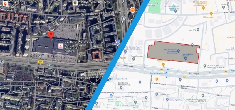
New Geocoding API Feature: Building Outlines
Google has recently introduced a highly-anticipated enhancement to the Geocoding API—Building Outlines. This new feature significantly improves the “last 100 meters” challenge that many logistics and delivery services face. The API now provides the outline of buildings, offering a more detailed view of the structure’s footprint. This can be especially useful for applications that require an understanding of the building’s size and layout, such as emergency response planning or detailed mapping services.
This feature is now available in Unrestricted Preview, meaning developers can start integrating these capabilities into their applications immediately.


Results of building outlines for the following addresses/Place IDs:
Left: Górczewska 200, 01-460 Warsaw, Poland / ChIJZbhi_R3LHkcRm3ppDENu1NE
Right: Górczewska 124, 01-460 Warsaw, Poland (Wola Park) / ChIJ2VHq4Q_LHkcR5EtlppMlnRI
Enhance Your Location-Based Services with the Geocoding API
The Google Maps Geocoding API is a robust tool that goes beyond simple address conversion, offering features that enhance precision and usability in location-based services. With the recent addition of building outlines, this API addresses a critical need in the market, helping businesses improve user experiences and operational efficiency.
If you’re looking to implement these features or want to explore how the Geocoding API can benefit your business, contact us today. As a Google Premier Partner, we can guide you through the process and ensure you get the most out of Google Maps Platform’s tools!